Geography of india
Geography of india

Land
India is a land of diverse geographical features. From the snow-capped peaks of the Himalayas to the sandy beaches of the Arabian Sea, the country boasts of a wide range of terrain, climate, and natural resources. India's geography has played a significant role in shaping its history, economy, culture, and politics.
Location and Size
India is the seventh-largest country in the world, covering an area of 3.28 million square kilometers. It lies in the southern part of Asia and shares its borders with Pakistan to the west, China, Nepal, and Bhutan to the north, Bangladesh and Myanmar to the east, and Sri Lanka to the south. The country has a coastline of about 7,500 kilometers, which runs along the Arabian Sea in the west, the Bay of Bengal in the east, and the Indian Ocean to the south.
Mountains and Plateaus
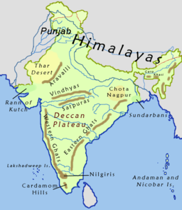
India is home to some of the world's highest mountain ranges, including the Himalayas, the Karakoram Range, and the Hindu Kush Range. The Himalayas, which run across northern India, Nepal, Bhutan, and Tibet, are the highest mountains in the world, with the highest peak being Mount Everest. The Himalayas act as a natural barrier between India and China, and they have shaped the country's climate, culture, and history.
The Indian subcontinent is also characterized by several plateaus, including the Deccan Plateau, which covers much of southern India, and the Chota Nagpur Plateau, which covers parts of eastern India. The Deccan Plateau is a vast volcanic plateau, with an average elevation of about 600 meters above sea level. It is surrounded by the Eastern and Western Ghats, which are a range of hills that run parallel to the coast.
Rivers
India is home to several major rivers, including the Ganges, the Brahmaputra, the Yamuna, the Godavari, the Krishna, and the Narmada. These rivers play a crucial role in the country's agriculture, economy, and culture. The Ganges, which is considered a sacred river by Hindus, is the most significant river in India, with a length of about 2,525 kilometers. It flows from the Himalayas, through northern India and Bangladesh, before emptying into the Bay of Bengal.
The Brahmaputra, which originates in Tibet and flows through northeastern India and Bangladesh, is one of the largest rivers in the world. It is about 2,900 kilometers long and is an important source of water for irrigation and hydroelectric power.
Deserts
India has two major deserts, the Thar Desert, which covers much of western India and Pakistan, and the cold desert of Ladakh, which lies in the northernmost part of India. The Thar Desert, also known as the Great Indian Desert, is one of the hottest and driest places in the world, with temperatures reaching up to 50°C during the summer. Despite its arid climate, the Thar Desert is home to a variety of plants and animals, including cacti, snakes, and antelopes.
Coastline
India has a long coastline of about 7,500 kilometers, which runs along the Arabian Sea, the Bay of Bengal, and the Indian Ocean. The coastline is dotted with several ports, including Mumbai, Chennai, and Kolkata, which are important centers of trade and commerce. The coastal region is also home to several important ecosystems, including mangrove forests, coral reefs, and estuaries.


Comments
Post a Comment